Advertisement

Flooding along the Mississippi seen from space

On Jan. 11, the Lower Mississippi River stood at 54 feet and rising.

By Brooks Hays
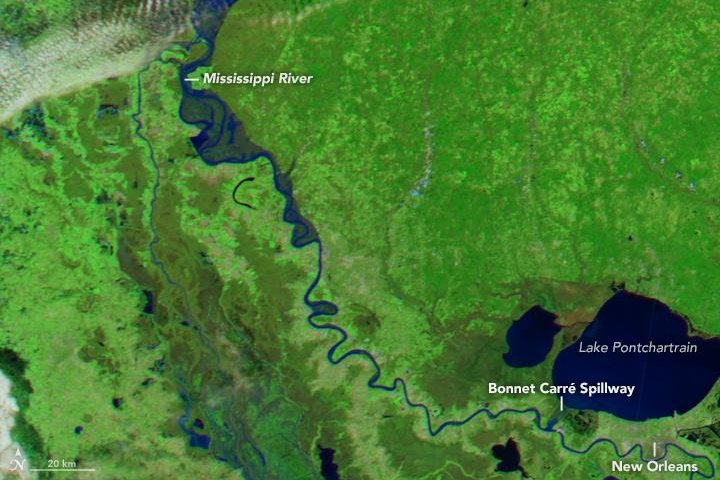
NASA's Aqua satellite photographed rare winter flooding on the Lower Mississippi in Louisiana. Photo by NASA/EO
1 of 2 | NASA's Aqua satellite photographed rare winter flooding on the Lower Mississippi in Louisiana. Photo by NASA/EO

NEW ORLEANS, Jan. 16 (UPI) -- After intense winter rains fell in the middle of the United States, much of the South suffered devastating effects downriver. In Louisiana, the flooding was expansive enough to be seen from space.

A new image, captured on Jan. 11 by NASA's Aqua satellite, shows Louisiana's Lower Mississippi swollen with flood water that arrived from up north.
Advertisement

Flooding in the region was substantial -- and unusual. It was only the second time in 200 years of records that a winter flood cracked the top-40 list of flood crests in St. Louis, Missouri.

Researchers say a combination of factors enabled the flooding. That included precipitation from El Nino-inspired storms that might have normally fell as snow arrived in the form of rain thanks to unusually warm winter weather in the Midwest. And an already saturated and frozen ground prevented the soil from absorbing much of that precipitation.

"There has been much higher than normal rainfall over the southern and central portion of the Mississippi basin this winter, attributed to the strong El Nino," John Kimball, an expert in hydrology and ecology at the University of Montana, told NASA. "This led to soil saturation and more rapid and abundant runoff than in a normal winter."

Advertisement

The image, snapped by Aqua's MODIS camera, shows flood waters arriving south after a week-long trip down the Mississippi. On Jan. 11, the river stood at 54 feet and rising.

A second image, from around the same time last year, reveals the Lower Mississippi at more normal water levels.

Latest Headlines