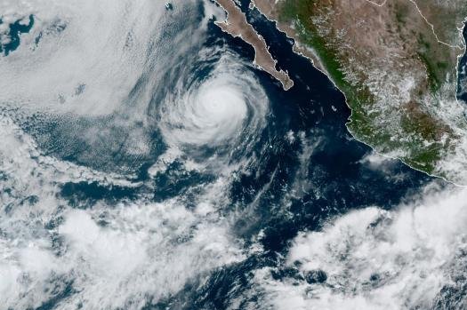
Elida was located about 275 miles southwest of the southern tip of Baja California, Mexico, as of Tuesday morning. Photo courtesy of NOAA
Aug. 10 -- Hurricane Elida formed on Monday afternoon and continued to strengthen into early Tuesday morning. The Category 2 hurricane is the first organized tropical system since Douglas impacted Hawaii almost two weeks ago.
Elida was located about 275 miles southwest of the southern tip of Baja California, Mexico, and was packing maximum sustained winds of 100 mph. The storm was moving in a northwest direction at 14 mph, the National Hurricane Center said in its 9 a.m. MDT advisory.
AccuWeather meteorologists said prior to Elida's formation, conditions in the East Pacific haven't been conducive to tropical development. But that has since changed.
"For a variety of reasons, conditions have not been favorable in the eastern Pacific Ocean for nearly two weeks," said AccuWeather senior meteorologist Mike Doll.
But now, warm waters off the southern coast of Mexico have become the breeding ground of tropical activity.
Elida originated as Tropical Depression Nine-E, which formed 315 miles south-southeast of Manzanillo, Mexico, on Saturday evening, and then strengthened to Tropical Storm Elida early Sunday morning with maximum sustained winds of 40 mph.
Despite reaching Category 2 status, Elida is expected to rapidly weaken by Tuesday night.
The last time the name Elida was used was in 2014 for a tropical storm that formed late in June of that year. The 2014 East Pacific tropical season was the fifth-busiest in history with 22 named storms and nine major hurricanes. Meanwhile, the Atlantic Ocean only had nine named storms total that season.
"Ocean water temperatures are 86 to 88 degrees F (near 31 C), which combined with low wind shear, has made for a favorable environment for the tropical system to strengthen," explained Doll.
Fortunately, the strengthening tropical storm will not have any direct impacts to land.
Still, shipping interests in the region should be aware of rougher seas stirred up by Elida, and stronger rip currents may be noticeable at the southern Mexico beaches as well as Baja California.
Wind intensity will decrease with the system as it moves into cooler waters beyond the middle of the week.
Following closely behind, a second feature is likely to develop during the second half of the week. Steering breezes would also keep this system away from the southwestern coast of Mexico.
However, there is another area meteorologists will watch closely. That feature will emerge off the west coast of Central America later this week and could evolve into a tropical depression this weekend. The track of this feature could take it close to the coast next week.
A third potential development area in the central Pacific Ocean is slowly tracking westward and approaching the central Pacific this week. At this point in time however, impacts to Hawaii seem unlikely.
The next storm names on the list for the East Pacific hurricane season are Fausto and Genevieve.
"The Atlantic and Pacific Basins are connected in a way when it comes to tropical development. Usually, during the time that the Atlantic Ocean is very active with several storms, the East Pacific will be quieter, and visa versa," explained AccuWeather meteorologist Jake Sojda.
Large-scale weather patterns like El Nino, and La Niña are some of the factors that contribute to which basin is active when.
"As the East Pacific looks to turn more active through mid-August, the focus is likely to return to the Atlantic basin by the end of the month," said Doll.
After having a stretch of five record-earliest named tropical systems in a row for the Atlantic 2020 season, ending with Isaias, AccuWeather meteorologists are still monitoring a few tropical waves in the Atlantic Ocean for potential development through mid-August.


