Advertisement

Tropical Cyclone Herold drenches northeastern Madagascar

By Maura Kelly, Accuweather.com
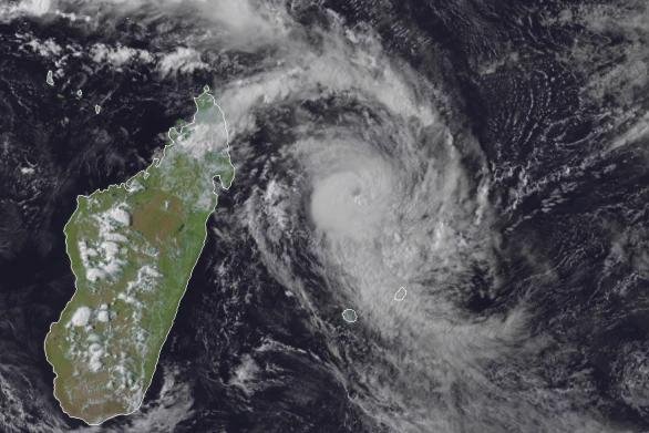
This satellite image from Monday afternoon shows Tropical Cyclone Herold to the east of Madagascar in the South Indian Ocean. Photo by CIRA RAMMB

After meandering near the northeastern corner of Madagascar as a tropical storm, a tropical cyclone developed on Sunday and was given the name Herold.

On Saturday, Herold produced 206 mm of rain in Sambava and 104 mm of rain in Antalaha, both located along the northeastern coast of Madagascar.
Advertisement

As of late Monday local time, Tropical Cyclone Herold is equivalent in strength to a Category 2 hurricane in the Atlantic and East Pacific basins.

The storm is forecast to follow a southeasterly path through the middle of the week and pass to the northeast of the island of Maurice.

Periods of rain, thunderstorms and gusty winds are in the forecast into Tuesday as the storm's outer rainbands sweep over the island.

However, if Herold drifts farther south, heavier rain and damaging wind gusts could reach the island and the outer rainbands could brush the island of La Reunion to the southwest.

By the second half of the week, Herold will move into a harsher environment and will eventually weaken and transition into a nontropical storm.

The storm will continue to move away to the southeast over the southern Indian Ocean with no impact to land.

Advertisement

Latest Headlines