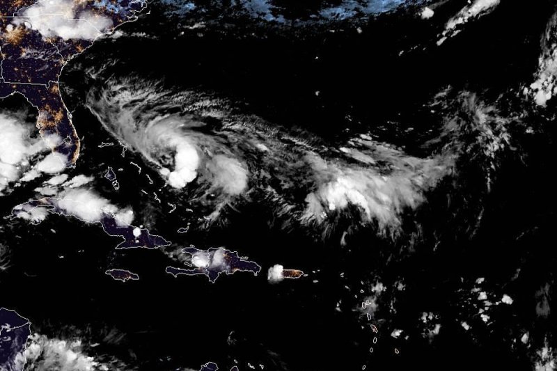
Tropical storm watches were in place in Florida. Photo courtesy of NOAA
Sept. 12 (UPI) -- Residents and officials along the southeastern coast of the United States are once again on alert for a brewing tropical system in the Atlantic, just over a week after Hurricane Dorian lashed the region.
AccuWeather meteorologists are closely monitoring a mass of clouds, downpours and gusty thunderstorms moving northwestward over the Bahamas that evolved into Tropical Depression Nine on Friday afternoon and is forecast to become a tropical storm into this weekend.
As of 8 p.m. EDT Friday, Tropical Depression Nine was located about 155 miles east-southeast of the Dorian-battered Great Abaco Island and had maximum sustained winds of 30 mph. The National Hurricane Center said a hurricane hunter aircraft was investigating the disturbance and has found that the center is forming farther to the east than pondered earlier in the day.
This development is critical for the severity of impacts on the Bahamas and proximity of the track to the U.S. coast.
If the system strengthens into a tropical storm, it will be named Humberto, the eighth-named tropical system of the 2019 Atlantic season. The upgrade could occur at any time through Saturday.
"Warm water, weakening wind shear and also the dry air is going to be dissipating, which is conducive for development," AccuWeather Chief Broadcast Meteorologist Bernie Rayno said of the favorable conditions.
Water temperatures surrounding the Bahamas and Florida's Atlantic coast on Friday were in the low to mid-80s.
As the storm strengthens, forecasters project it will take a path that is somewhat similar to the one Dorian took, but farther out to sea since the center is forming farther east.
"The strengthening storm is forecast to take a curved path with initial movement to the northwest through Saturday, then the north from Sunday to Monday and perhaps a turn to the northeast from Monday to Tuesday," AccuWeather Hurricane Expert Dan Kottlowski said.
This anticipated path will take the center of the storm just northeast of the Bahamas, well east of the Atlantic coast of Florida then well off the Georgia and Carolina coasts. However, recall that Dorian moved in from the east and stalled over the northern Bahamas. This storm is not likely to stall and will drift up from the southeast.
Tropical storm watches were issued along a stretch of Florida's east coast Friday morning. This includes areas from Jupiter Inlet to the Flagler-Volusia County line.
However, the exact track in the short term will depend on how quickly the storm strengthens and how much influence high pressure over the Atlantic Ocean and a storm in the upper atmosphere over the Gulf of Mexico have.
It is not out of the question that this storm could develop into a hurricane, especially since it is more likely for the center to avoid direct contact with the U.S. mainland and the large islands of the Bahamas.
A tropical cyclone that reaches strong tropical storm or minimal hurricane strength is more likely to take a sharp curved path. A weak and poorly organized tropical depression or weak tropical storm is more likely to take a more westward track that could be inland of the coast in Florida and Georgia for a time.
Wind shear is forecast to decrease over the path of this system, when combine with sufficiently warm water, some strengthening is likely.
"Next week, a non-tropical storm moving through the northeastern U.S. may exert enough influence to sweep the tropical system out to sea and avoid direct impact in the Northeastern states," Kottlowski said.
"However, if that non-tropical storm fails to grab the tropical system, a more northerly track along the mid-Atlantic and New England coasts may occur."
At this time, AccuWeather is projecting a RealImpact Scale of less than one in the United States. However, this can change depending on the track, strength and forward speed of the tropical feature.
Despite the center forming farther to the east, enough rain is likely to wrap around the western side of the storm to produce torrential downpours over parts of the central and northern Bahamas. This includes areas that were missed by Dorian's wrath and those that were hit head-on by the Category 5 hurricane last week.
A general 2 inches to 4 inches of rain is forecast over the Bahamas and in east-central and northeastern Florida. However, an AccuWeather Local StormMax of 8 inches is forecast for the central and northern Bahamas.
Torrential rain, flash flooding and exposure to the elements are the most immediate impacts to those without solid shelter as well as cleanup and recovery operations on Abaco and Grand Bahama.
As the storm slowly brews, winds will begin to ramp up in the clusters of thunderstorms. Seas and surf will correspondingly build northward around and ahead of the storm as it moves along the projected curved path. These conditions are expected even if the center remains at sea.
Beachgoers should avoid venturing far into the surf due to the increasing risk of large waves and frequent and strong rip currents.
Boaters should remain within the protection of ports or the Intercoastal Waterway until the threat from the storm has passed.
People from the northern Bahamas and the east-central coast of Florida the upper-east coast of Florida should secure their property for tropical storm gusts this weekend. These conditions can occur whether the center remains well offshore.
There are other features AccuWeather meteorologists are monitoring over the Atlantic Basin. This includes one system over the central Atlantic that may approach the Caribbean islands while strengthening early next week.


