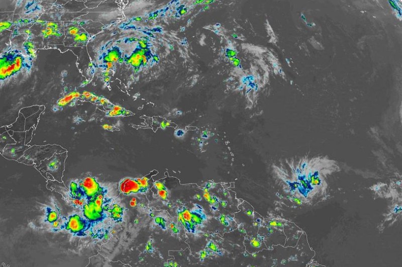
Tropical Storm Dorian, the storm in the lower right of the image, is forecast to become a hurricane by Tuesday afternoon. Image courtesy of NOAA
Aug. 24 (UPI) -- A tropical wave to the east of the Lesser Antilles that AccuWeather meteorologists have been monitoring for possible development over the past few days became Tropical Storm Dorian on Saturday afternoon.
The feature is expected to reach the Windward Islands around Tuesday or Wednesday.
"Gusty winds and locally heavy rainfall are likely to reach the Leeward Islands Tuesday and Tuesday night," Pydynowski said.
It is possible that this feature may be a strong tropical storm or perhaps even a hurricane at this point, depending on how much wind shear it encounters.
All interests from Cuba to Hispaniola and Puerto Rico should closely monitor the path of this feature as it crosses the Lesser Antilles and eventually reaches the eastern Caribbean.
Elsewhere over the Atlantic Basin, Chantal, which was once a tropical storm, has dissipated.
As additional tropical waves emerge from Africa, there will be an ongoing risk of development as wind shear, dry air and dust diminish over the Atlantic Basin in the coming weeks.
This is the time of the year when development can occur just about anywhere over the Atlantic, which means well at sea or near the coast of North America.
People should not expect the quietness of June, July and the first part of August to be a reflection on what the balance of the Atlantic hurricane season will bring.
AccuWeather meteorologists anticipate that multiple tropical storms and/or hurricanes to be in progress at the same time in the coming weeks.


