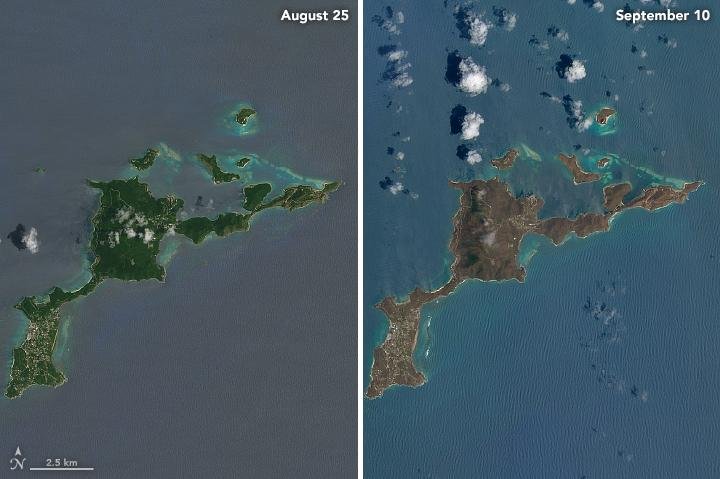
The terrain on the island of Virgin Gorda is noticeably different in from the photo on the left, taken August 25, when compared to the photo on the right, taken after Hurricane Irma passed through on September 10. Image courtesy NASA
Sept. 12 (UPI) -- NASA released satellite images of islands in the Caribbean showing the devastations wrought there by Hurricane Irma.
While closeup damage of specific structures can't be seen in the photographs, there is a stark difference in the color of the islands. Before the hurricane there are a dark green, while after the Category 5 storm, they are a dull brown.
"The most obvious change is the widespread browning of the landscape," NASA said in a blog post. "There are a number of possible reasons for this. Lush green tropical vegetation can be ripped away by a storm's strong winds, leaving the satellite with a view of more bare ground. Also, salt spray whipped up by the hurricane can coat and desiccate leaves while they are still on the trees."
Irma made first landfall on Wednesday, causing destruction on the island of Barbuda. The government there said up to 90 percent of buildings were damaged or destroyed. It moved on to Anguilla, St. Martin, St. Parts and the British and U.S. Virgin Islands before passing near Puerto Rico.
On Thursday, Irma caused flooding in the Dominican Republic and Haiti before hitting the Turks and Caicos Islands in the Bahamas. On Friday and Saturday the storm passed over Cuba before heading north to make landfall in the Florida Keys.
Residents throughout the region say food is scarce and in some cases looting is a concern.
UNICEF, the United Nations' children's relief fund, called on the international community to provide help to those affected by the storm in the Caribbean.
"People are concerned, there is a general sense that [the British Virgin Islands] is British government territory and therefore the British will handle it," Khin-Sandi Lwin, who is leading the organization's response there, told The Guardian.
"So we haven't been able to raise the funds from other governments at the moment. This is where I do think we need a much bigger international response to the funding that's needed.
"At the moment we are operating on regular funds we have for our ongoing programs. We put aside money -- about $800,000 -- to get our first response up, but it means our regular programs into next year will be down. We do need that additional funding -- about US$2.3m."
Virgin Atlantic CEO Richard Branson, who lives on the British Virgin Islands' Necker Island, has called for a new Marshall Plan to help the region.
On Tuesday, the leaders of the countries that control some of the islands planned to visit the territories. French President Emmanuel Macron planned to survey damage on the French-controlled portion of St. Martin; the other side of the island, St. Maarten, is controlled by the Netherlands.
British Foreign Secretary Boris Johnson, meanwhile, plans to visit the British Virgin Islands and Anguilla in the "coming days."


