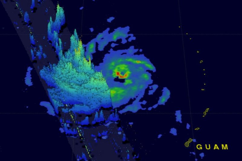
An image from NASA’s Global Precipitation Measurement core observatory satellite shows heavy rainfall on the southern side of Super Typhoon Soudelor's eye. Image courtesy NASA
WASHINGTON, Aug. 3 (UPI) -- Super Typhoon Soudelor intensified into the strongest storm of 2015 on Monday after causing flooding and destruction on the island of Saipan overnight, weather officials said.
As of 5 p.m. local time Monday, the Joint Typhoon Warning Center said Soudelor had strengthened into the equivalent of a Category 5 hurricane, featuring maximum sustained winds of 180 mph and gusts up to 220 mph, The Weather Channel reported. To qualify as a super typhoon, a storm must feature winds of at least 150 mph.
The super typhoon is expected to travel west-northwest, bringing it near Japan's southwest Ryukyu Islands, Taiwan and eastern China on Friday. The Weather Channel report said the storm should weaken by time it hits land there, though it will still be strong. As of Monday morning the storm was moving 13.8 mph, NASA said.
Soudelor passed over Saipan late Sunday night into early Monday, Pacific Daily News reported. High wind gusts ripped off roofs from homes and power poles were toppled. The island's power plant was also flooded.
"I've seen multiple primary power poles down; I've seen cars flipped over the road; I've seen lots of torn roofs," John Hirsh, executive director of the American Red Cross in Saipan, told the newspaper.
Acting Gov. Ralph DLG Torres declared "a state of disaster and significant emergency," said Ivan Blanco, press secretary at the governor's office in the Commonwealth of the Northern Marianas.
Meanwhile, NASA's Global Precipitation Measurement core observatory satellite flew directly over the super typhoon around 7:04 a.m. EDT on Monday. A news release from the agency said the satellite "had a very good view of heavy rainfall associated with Soudelor."
Rain was falling at a rate of 2.3 inches per hour on the southern side of the eye.
The Weather Channel said the strongest typhoon this year prior to Soudelor was Cyclone Pam, which reached peak estimated sustained winds of 165 mph in March.


