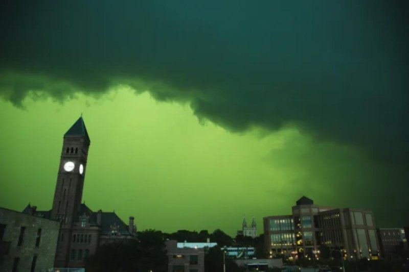
The sky turns green during a severe storm in downtown Sioux Falls, S.D., on Tuesday. Photo by Jkarmill/Twitter via AccuWeather
July 6 -- As millions of Americans found themselves in the path of severe storms on Tuesday, one state in particular received a colorful concoction in the skies as rain and hail fell.
Storms passed through South Dakota during Tuesday afternoon, leaving behind considerable rainfall, hail and wind reports. The most unique portion of the severe weather came in its particular hue, eschewing the typical gloomy grey skies for a green shade more in common with night vision goggles than daytime thunderstorms.
The hue covered the South Dakota hub of Sioux Falls throughout the late afternoon hours.
For an explanation of the sharp contrast in colors, AccuWeather Meteorologist Isaac Longley points to the late-afternoon fuel source of the storms.
"Thunderstorms tend to occur later in the day due (to) the sun's energy during the day helping to fuel them," Longley stated. "As we know, the sun appears more red later in the day as it approaches the horizon."
Once light underneath tall thunderclouds is introduced, the combination of red sunlight and blue lights leads to the green colors engulfing the sky.
"Light underneath a tall thundercloud appears blue due to the scattering by water droplets," Longley said. "When the blue light is illuminated by the red light from the setting sun, it appears green, which is why some thunderstorms have that greenish hue to it."
Video taken from Sioux Falls amid the strong winds, thunderstorms and hail is covered in the greenish color, which was the view for many residents in the area:
Sioux Falls was slammed with more than 3 inches of rain within a few hours of the storms starting up Tuesday, while wind was also a top concern.
Top wind gusts reported in South Dakota Tuesday included a 96-mph gust in Huron, as well as immense gusts felt in Agar (91 mph), Ree Heights (87 mph) and Wall Lake (85 mph).
Storms are expected to push into part of the Upper Midwest by evening hours, with thunderstorms forecast to potentially become clustered, upping the threat level across a greater expanse of land in the region.
"Typically, severe thunderstorm wind damage tends to be much more localized to a part of a community, whereas this cluster of thunderstorms may create widespread damage over a much larger area," AccuWeather Meteorologist La Troy Thornton explained.


