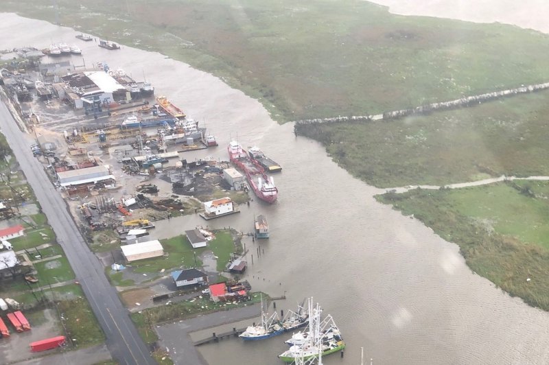
1 of 3 | Flooding from Hurricane Ida is seen along the Gulf Coast in Louisiana on August 30. Meteorologists say two developing disturbances in the Atlantic Ocean could land somewhere in the U.S. Photo by U.S. Coast Guard/UPI |
License Photo
Sept. 17 (UPI) -- Forecasters are monitoring two storm systems in the Atlantic basin -- and potentially a third -- that could ultimately take aim at the United States as a tropical storm or hurricane in the near future.
One storm, designated by the National Hurricane Center as 96L, is just off the U.S. Mid-Atlantic coast -- and the other, 95L, formed off the western coastline of Africa earlier this week. Both have trajectories that could impact the U.S. mainland.
The NHC said Friday that there's a 70% chance that 96L will become a tropical system in the next two days, and a 70% that 95L will do so over the next five days.
Both potential systems are in the basin just days after Hurricane Nicholas arrived in Texas this week and Hurricane Ida landed in the Gulf Coast a couple weeks ago. Ida moved across the eastern United States and ultimately caused severe flooding in the Northeast that killed dozens of people.
System 96L, off the North Carolina coast
"Environmental conditions are becoming more conducive for development, and a tropical depression is likely to form during the next day or so while the system moves northward to north-northeastward off the southeast and mid-Atlantic U.S. coasts," the NHC said Friday about the system lurking just off North Carolina.
"This system could bring high surf to portions of the southeast and mid-Atlantic U.S. coasts through this weekend."
![]()
System 96L is seen off the Mid-Atlantic U.S. coast early Friday. Image courtesy NOAA/NHC
The system was struggling a bit on Thursday to get its act together due to disruptive northerly winds and dry air in the vicinity, but there are other factors that favor strengthening.
Meteorologists believe that while the center of this system will stay offshore of the mid-Atlantic and New England regions, enough of a circulation will develop to stir winds and create waves that propagate outward from the center of the storm into Saturday.
The system could ultimately make landfall somewhere in the Mid-Atlantic or Northeast, or miss both.
If it turns into a named storm, the next names on the list are Odette and Peter.
System 95L, near the Cabo Verde Islands off Africa
The other system, still near the African coast, could morph into a tropical depression this weekend, the hurricane center said.
"This system is expected to move westward to west-northwestward at 15 to 20 mph across the tropical Atlantic during the next several days."
A couple of hundred miles of difference in track while it moves over the central and west-central Atlantic may determine if 95L, as a named system, will impact the U.S. East Coast.
"The disturbance is tracking across the central Atlantic at a rapid pace, and this likely explains why the system has yet to develop a well-defined low-level circulation," AccuWeather Senior Meteorologist Randy Adkins said.
![]()
System 95L, center-right, is seen off the western coast of Africa early Friday near the Cabo Verde Islands. Image courtesy NOAA/NHC
Even if the system remains poorly organized, locally drenching showers and gusty thunderstorms can spread westward across the Leeward Islands beginning late this weekend. It may pass close to the islands early next week.
A large southward dip in the jet stream may create strong wind shear and westerly winds in general near the East Coast of the United States later next week. If this occurs and the system takes a path well north of the Leeward Islands, it could be steered northward over the middle of the Atlantic and completely miss the United States.
If the system takes a more southerly route this weekend and early next week, it could wander farther west near the islands over the northern Caribbean, Florida and possibly the Gulf of Mexico.
There's also a third disturbance -- just off the coast of western Africa -- but the NHC projects just a 20% if could become a tropical system over the next five days. If, however, it did develop, it might also pose a threat to the United States.
So far, there have been 14 named storms in the Atlantic basin in 2021. Six have turned into hurricanes and three became major hurricanes, with a strength of Category 3 or higher. Eight systems have impacted the United States.
AccuWeather projects 20-25 named storms by the time hurricane season ends on Nov. 30, with as many as 10 hurricanes and five to seven major hurricanes. One or two more systems, forecasters say, may have a direct impact on the United States.
So far this year, the named storms have been Ana, Bill, Claudette, Danny, Elsa, Fred, Grace, Henri, Ida, Kate, Julian, Larry, Mindy and Nicholas. Elsa, Grace, Henri, Ida and Nicholas became hurricanes.
The next names on the list are Odette, Peter, Rose, Sam, Teresa, Victor and Wanda.


