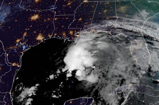
This is a satellite image taken Friday of the system in the Gulf of Mexico that could become Tropical Storm Claudette later in the day. Photo courtesy of the National Oceanic and Atmospheric Administration
June 18 (UPI) -- Heavy rains and gusty winds reached the northern Gulf Coast late Friday morning as a potentially dangerous storm system crept closer to land.
The system, which is expected to grow into a tropical storm before landfall, was 220 miles south of Morgan City, La., on Friday. A tropical storm warning remained in effect for a large portion of the Gulf Coast, from Intracoastal, La., to the Okaloosa/Walton County line in the Florida Panhandle.
Metropolitan New Orleans and Lake Pontchartrain remained in the system's target area.
Sustained winds for the system remained at 35 mph, 4 mph short of minimum tropical storm strength. If it becomes a tropical storm, it will be called Claudette. Forecasters predict it will reach land along the north-central Gulf Coast Friday night or Saturday morning.
The National Hurricane Center said there is a 90% chance the storm will be elevated to at least a tropical storm over the next 48 hours to five days.
"Rainfall totals of 4 to 8 inches with isolated maximum amounts of 12 inches are expected across portions of the central Gulf Coast beginning today," the NHC said in a statement. "Considerable flash, urban and small stream flooding impacts, as well as new and renewed minor to isolated moderate river flooding, are likely."
AccuWeather senior meteorologist Rob Miller said the system likely won't become stronger than a tropical storm.
"While there continued to be a low-level circulation evident over the southwestern Gulf, winds blowing at different directions and strength higher up in the atmosphere, known as wind shear, were preventing organization and gathering of moisture near the center of the storm just above the surface of the water," he said.
Forecasters predict the system to continue its current movement over the upcoming days, approaching the north-central Gulf Coast by early Saturday. The system is expected to move slowly northeast as it crosses the southeastern United States.
Heavy rain could span across southeastern Mississippi, southern and central Alabama and central Georgia once the system reaches land, dumping rainfall totals of 3 to 5 inches, with isolated maximum amounts of 7 inches in some areas.
Coastal storm surge may reach 2 to 3 feet in the affected areas, the NHC said.
The threat of tornadoes produced by the system could start Friday afternoon across coastal Louisiana and spread overnight into Saturday across southern portions of Louisiana, Mississippi and Alabama, to the western Florida Panhandle, forecasters said.


