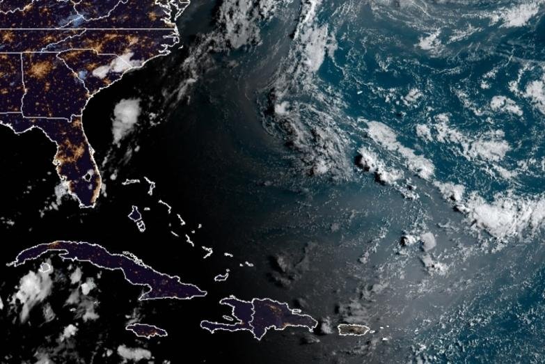
The Atlantic basin is seen early Wednesday without any disturbances that could develop into a tropical system. Image courtesy of NOAA/NHC
Following Isaias's damaging blow to the Carolinas and northward along the Interstate-95 corridor of the Northeast, a lull in tropical activity lasting a week or so prior to the middle of August may be in the cards for a record-setting season for the Atlantic basin.
However, given the pace of tropical development in the 2020 season thus far, it may be on borrowed time with the heart of the hurricane season looming.
"We are looking at some changes for this week that may last into the first part of next week, which may limit tropical development over the main part of the Atlantic," according to AccuWeather's top hurricane expert, Dan Kottlowski.
"A large high-pressure area that usually resides between Bermuda and the Azores is shifting southward this week," Kottlowski said. "In turn, this will cause the belt of northeast trade winds to shift farther south and strengthen into the zone where we usually have the parade of tropical waves heading westward."
The pattern change will increase wind shear, or changing winds with altitude, and the flow of dry air over the zone where many tropical systems are born.
Any tropical disturbance, or tropical wave, that moves along through this zone has a high chance of getting torn up and any better organized feature in there would tend to struggle with development.
![]() |
| This image of the Atlantic basin, taken Tuesday, shows that dry air (yellow, orange and red shading) has pushed southward over much of the tropical Atlantic. Pockets of moisture (blue) remain from the Bahamas and Greater Antilles to near Bermuda and over western Caribbean and part of the Gulf of Mexico. Image by NOAA/GOES-East |
Forecasters have been keeping an eye on a pocket of showers and thunderstorms to the southwest of Bermuda that has a chance of development over the next few days. However, this risk has diminished from a high chance last weekend, to a medium chance on Monday to about at 10 chance.
"Moisture associated with the disturbance near Bermuda looks ragged compared to this past weekend, so it has [likely] missed its chance for development," Kottlowski said.
The latest status in the Atlantic does not mean that there is a zero percent chance of anything taking shape as far as tropical systems are concerned, but small features compared to the overall scope of the basin and the local atmospheric environment can become favorable for development on a small scale.
"We expect the high to retreat northward next week and the function of tropical waves moving westward from Africa will have less resistance and perhaps more likely to spur development," Kottlowski said.
The 2020 season has produced a bumper crop of tropical storms with nine tropical storms and a tropical depression. Of the nine tropical storms, two -- Hanna and Isaias -- have gone on to strengthen into hurricanes.
The average date for the first hurricane of the Atlantic season is not until Aug. 10.
Cristobal, Edouard, Fay, Gonzalo, Hanna and Isaias have set early-season formation records for their designated letter. Storms are named in alphabetical order during the season. Should a season run out of letters of the alphabet, then Greek letters are used.
Storms from Edouard through Isaias have truncated the infamous 2005 season early formation records surpassing Emily, Franklin, Gert, Harvey and Irene.
Despite the upcoming lull, there is a significant chance that the "J" and "K" storms may also set early formation records, both of which were set in 2005. Jose formed on Aug. 22, and the blockbuster Katrina formed on Aug. 24.
In terms of named systems, 2020 has been busier than the entire 2014 season, which only spawned eight tropical storms through the end of October. The first system formed on July 1 in 2014, compared to May 14 of this year.
The peak of hurricane season is not until around the middle of September. The average number of tropical storms and hurricanes typically do not ramp up until the latter part of August and the tropics tend to stay rather busy through much of October.
With the bulk of the hurricane season still several weeks away, the potential is there for many more named systems and especially several more hurricanes, some of which are likely to be major hurricanes of Category 3 strength or greater. And there is the potential for this season to remain active through the end of November and perhaps into December.
The record for the greatest number of named systems for the Atlantic basin belongs to 2005, when 28 storms of at least tropical storm strength occurred. AccuWeather's hurricane experts are projecting the 2020 season to come in at number two in terms of the number of named systems, surpassing 19 held by the 1995, 2010, 2011 and 2012 seasons. Each of those years brought at least seven hurricanes and at least two major hurricanes.
Many more tropical storms are likely to develop over the Atlantic basin in the coming months, including more hurricanes, some of which can be especially powerful.
The AccuWeather's initial 2020 forecast in March called for 14-18 tropical storms, seven to nine hurricanes and two to four major hurricanes. After a review of new forecasting data in May, projections were increased to 14-20 tropical storms, seven to 11 hurricanes and four to six major hurricanes. At the end of July, experts pushed forecast numbers even higher.


