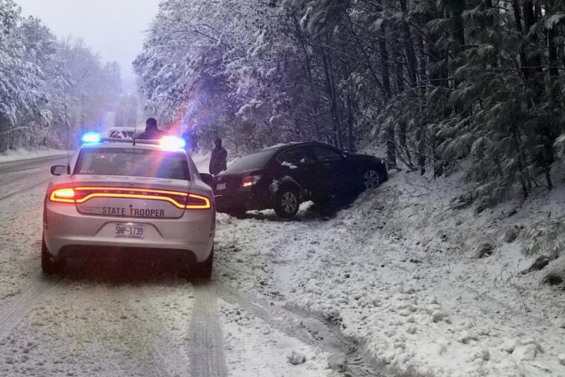
Officials said black ice caused crashes throughout North Carolina. Photo courtesy of the North Carolina Highway Patrol
Feb. 21 (UPI) -- A quick-hitting storm painted a wintry scene across the Carolinas and Virginia on Thursday, spreading snow across some of the region's largest cities.
Spreading the first measurable snowfall in central North Carolina in 437 days, the storm snapped the snow drought with icy impacts. Even officers found themselves stricken by the icy conditions, as the Department of Public Safety tweeted as a State Capitol Police officer was involved in an accident in Raleigh while driving to work on Friday. She was reportedly treated for non-life threatening injuries.
On Friday morning, the state's highway patrol urged motorists to "use extreme caution" when venturing onto the slick roads.
The last time North Carolina received extensive snowfall, hundreds of accidents swept the state, thousands of power outages left the state in the dark and three fatalities were tied to the storm.
While this year's storm was met with weeklong preparation, the wintry weather still caused disruptions to daily activities and left more than 25,000 customers without power as of 9 p.m. Thursday, according to PowerOutage.US.
The inclement weather also lead to the early closing of Mecklenburg County Board of Elections early voting sites and other county-sponsored evening programs.
No reported injuries or fatalities were connected with traffic accidents, although a numerous accidents reports were posted. On Interstate 95 near Fayetteville, a crash involving a tractor-trailer and a car closed a lane and backed up traffic for hours.
Air travel also saw hinderances at Charlotte Douglas International Airport. Despite deicing efforts, 230 flights at the airport were canceled and another 368 flights delayed, according to FlightAware.
Areas in Georgia, Tennessee, North Carolina and Virginia all saw at least 3.5 inches of snow, more accumulation than has fallen in Philadelphia, Baltimore and Washington, D.C., combined this winter (2.7 inches).
By the time night fell, the snow had come to an end for the western Carolinas and Georgia. Most of the accumulation had stuck in the mountainous regions while cities in lower elevations saw an inch or less of snow.
"The exception is Oconee and Pickens County, South Carolina, and far northeastern Georgia, where it was generally 2 to 4 inches at lower elevations and 4 to 8 inches above 3,000 feet," AccuWeather senior meteorologist Frank Strait said.
The Charlotte area saw no more than half an inch of snow, while the Greensboro and Winston Salem area saw 1 inch to 3 inches.
"Where the snow has ended, temperatures are below freezing or will fall below freezing (Thursday night). Lingering meltwater or slush on the roads will freeze solid, leading to icy patches on the roads and sidewalks," Strait said.
Snowfall has begun to wind down over eastern North Carolina and southeastern Virginia. As AccuWeather correctly predicted, the Raleigh area ended with a fresh 2 inches to 3 inches of snowfall across the metro area.
"Areas that see the heaviest snow will take more time to recover due to limited available resources for snow removal and treating the roads," Strait said. "Motorists in parts of eastern North Carolina and southeastern Virginia may not see the roads truly clear of snow or ice until Saturday afternoon, particularly the back roads in this area."
Earlier in the day, the state had ramped up preparations to mitigate the potential hazards of the rain and snow before the worst could set in. For many areas, that has meant school being canceled, businesses being closed and residents staying inside.
On Thursday morning, Gov. Roy Cooper said 29 school districts in the state would be closed for the day while 55 others were releasing students early in advance of the snow. As the storm progressed into Thursday night, North Carolina school districts announced delays or closings for Friday as well.
Excitement for the snow abounded among residents and students, such as the ones running to the window at McNair Elementary School in Browns Summit, N.C., to see the flakes falling.
"Naturally, as a Southern person, you're excited because it's snow and we don't normally have it," Rayna Yvars, a Raleigh resident told AccuWeather national reporter Bill Wadell. "But at the same, the whole state shuts down."
Others, such as Jenny Berry, said they never know what to expect in February, as one year the weather might allow for time on the beach and another year could bring snow.
"Oh, I love snow, I just don't like the ice that follows," Raleigh resident Sam Regaldo said. "It just melts a little, then it freezes again."
"This past week, we put the tanks on and made the decision to first hit hot spots like bridges and overpasses, so we loaded the trucks up [on Tuesday and Wednesday]," Jason Dunigan, a Wake County Maintenance engineer, told Wadell. "Started hitting bridges, hot spots, overpasses and exit ramps then the forecast changed from 1 inch to 3 inches, so we made the call to hit all of our bare pavement routes."
Dunigan added that trucks hit the road by 11 a.m. on Thursday morning, with an extra crew of contracted drivers coming in later in the day.
"There's definitely going to be some slick spots because temperatures are going to fall to 26, 27 degrees by [Friday] morning," Dunigan said. "We're just going to be here, we're going to be here all night long and throughout the morning ... we'll be ready for those."
Cooper pointed to whiteout conditions near the coast as a weather threat of specific concern for travelers.
The day's tumultuous precipitation began with rain before succumbing to the stormy weather, which crawled northeastward.
Reports and footage of snowfall from eastern Tennessee and northern Georgia began on on Thursday morning in areas such as Crossville, Tenn., where snow made for slick lanes on I-40 while elevated surfaces in the area measured 2 inches of accumulation.
Additional reporting by Bill Wadell.


