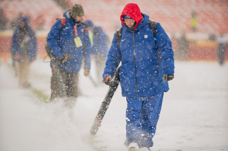
1 of 2 | Groundskeepers clear the field of snow before the Kansas City Chiefs take on the Denver Broncos at Arrowhead Stadium in Kansas City, Mo., on Sunday. Photo by Kyle Rivas/UPI |
License Photo
Dec. 15 (UPI) -- A swath of disruptive snow and ice will stretch from the mid-Mississippi Valley through the Northeast during the first part of this week. The wintry weather will come courtesy of a couple of disturbances shifting eastward out of the central part of the nation.
The first, bringing snow and ice and disrupting travel, sporting events and holiday shopping in the Plains on Sunday, will move east through the Ohio Valley Sunday night. By Monday morning, a mix of snow, sleet, and freezing rain will arrive in the mid-Atlantic.
The Kansas City metro area was hit with more than 4 inches of snow, sparking treacherous travel conditions and traffic jams.
The winter storm warning was issued for much of eastern Kansas and western Missouri, according to the National Weather Service.
The heavy snow didn't delay the Kansas City Chiefs vs. the Denver Broncos game or stop fans from tailgating, even though several Chiefs players had not arrived at Arrowhead Stadium as of two hours before kickoff, according to Adam Schefter of ESPN.
"Players who were caught in traffic and in accidents on the way to the stadium did call ahead to Chiefs' officials, and now all have made it, Schefter posted on Twitter.
"Though most of the heavier snowfall will be coming to an end in the evening, we expect snow showers to continue through the rest of Sunday night," AccuWeather Meteorologist Alan Reppert said.
"An additional 1-3 inches is possible the rest of the afternoon and evening for the area with totals of 4-8 inches by tonight. Untreated roads will be snow-covered and treated roads could be slick."
The Monday morning commute from Indianapolis to Pittsburgh to Baltimore and Philadelphia will feature some slick spots and commuters may have to allow for some extra time.
By Monday afternoon, some light snow and sleet will arrive from central New Jersey into the Tri-State area around New York City. It is unlikely to cause much disruption, as the combination of light precipitation and temperatures around or just above freezing will prevent much accumulation on roads.
This first round of snow and ice will dissipate Monday night in lieu of a new system taking shape behind it to the west.
The second system will be stronger, developing Monday in the lower Mississippi Valley. While severe thunderstorms take shape across parts of the Southeast, another round of snow and ice will develop on the storm's northern edge, impacting many of the same areas as the first round.
After getting a few inches of snow from the first round Sunday and Sunday night, St. Louis will have another few inches Monday into Monday night. From both systems combined, some locales in northern and central portions of Missouri into central Illinois can have around a foot of snow.
This system will then continue to strengthen as it moves into the mid-Atlantic and Northeast Monday night and Tuesday.
"The stronger storm will be more effective at drawing milder air northward later Monday into Tuesday," explained AccuWeather Meteorologist Eric Leister. "Places that see some wintry precipitation early Monday, like Baltimore and Philadelphia, will change to plain rain later Monday into Tuesday."
Portions of the Northeast that will largely miss out on any snow from the first disturbance, will get blanketed with several inches of snow from the second, stronger storm. This will primarily focus on northern Pennsylvania and much of upstate New York into New England.
"There is likely to be a narrow swath of 6- to 12-inch snowfall totals in the Northeast as well, but confidence remains low on exactly where that stripe will occur," said AccuWeather Senior Meteorologist Rob Miller.
"It does seem increasingly likely it will be from around the New York/Pennsylvania border northeastward through the Berkshires and Green and White Mountains."
Sandwiched between the snow and rain will be a corridor of potentially significant icing. Portions of central and eastern Pennsylvania into southern New England can have up to a quarter of an inch of icy glaze on elevated surfaces like hand railings, trees, and power lines. Any untreated surfaces would also become very slippery.
"Around a quarter of an inch of ice on trees and power lines is enough to begin causing some damage and can lead to some localized power outages," Miller said.
The widespread snow and ice across much of the interior Northeast will lead to very tricky travel on Tuesday. From State College, Pa., and Syracuse, N.Y., to Providence, R.I., and Portland, Maine.
By Tuesday night, the storm system will exit off the New England coast, ushering in another reinforcing cold shot for the Great Lakes and Northeast. The lake-effect snow machine will ramp up again, adding even more to some of the snow totals downwind of the Great Lakes.


