Residents in the Northeast will need all types of outerwear early this week as soaking rain and a surge of milder air will be quickly followed by tumbling temperatures and perhaps some snow.
AccuWeather meteorologists expect a variety of hazards ranging from reduced visibility from rain and fog to icy roadways due to a rapid freeze-up.
A storm will track from the central Plains to the Great Lakes and southeastern Canada spanning Sunday night to Monday night.
As snow and cold plunge into the Midwest behind the storm, mild and moist air will flow into the Ohio Valley and Northeast out ahead of it.
Periods of rain, areas of fog and milder conditions will accompany the approaching storm from Monday into Monday nig
The combination of the rain plus snowmelt will heighten the risk of flooding from northeastern Pennsylvania and northern New Jersey into interior parts of southern New England, AccuWeather Meteorologist Kyle Elliott said.
Portions of New York state and New England remain buried underneath a foot or more of snow following an impressive snowstorm during the first week of December. As much as 1-3 inches of water is locked up within this snowpack, the National Operational Hydrologic Remote Sensing Center reports.
"Some quick rises on small streams are likely with minor flooding possible in low-lying areas that are prone to flooding during heavy rain or spring thaw events," AccuWeather Senior Meteorologist Alex Sosnowski said.
"Some of the rivers may surge to bank full as well," he added.
Where no snow is on the ground, the risk of flooding will be highly localized.
Even in the absence of flooding, there will be hazards to motorists due to low visibility from downpours and fog, as well as a heightened risk of hydroplaning while traveling at highway speeds.
Airline passengers at the major hubs in the Northeast may face delays due to the rain and low cloud ceiling.
Ponchos will be a must for people heading to the City of Brotherly Love for the Monday Night Football game between the New York Giants and Philadelphia Eagles.
But fans will not need cold weather gear as temperatures will climb when the rain moves in.
On Monday, highs are forecast to surge into the 40s F across the northern tier and the 50s and 60s across part of the mid-Atlantic region.
Temperatures will climb even further Tuesday, with Washington, D.C.'s high set to flirt with its 1966 daily record of 67.
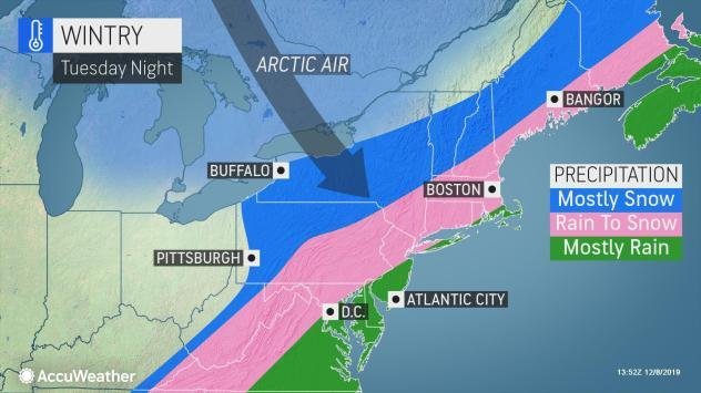
Arctic air to blast in behind rain, may cause changeover to snow
Residents will experience a temperature whiplash later Tuesday and Wednesday as Arctic air is unleashed in the storm's wake.
"It is not out of the question that the colder air behind the storm catches up with the rain Tuesday night resulting in rain ending as wet snow," AccuWeather Senior Meteorologist Bob Smerbeck said.
Given the prior mild conditions, it would have to snow at a steady rate in order for slippery conditions to develop on roadways with most accumulations expected on grassy and elevated surfaces.
However, AccuWeather meteorologists cannot rule out the potential for a slick Wednesday morning commute from the central Appalachians to the Interstate-95 corridor.
Regardless of if or how much snow falls, areas of slush and standing water can freeze as temperatures plummet in the Northeast, leaving untreated roads and sidewalks slipper
"Highs on Wednesday may be on the order of 20-25 degrees lower than Tuesday and struggle to reach the freezing mark by Thursday," Elliott said.
How long this cold air remains over the Northeast will be a key factor in determining whether yet another significant storm could bring winter weather or mostly rain to the region by next weekend.