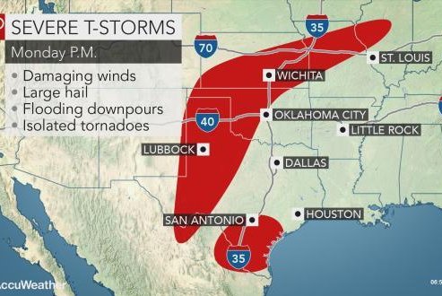
Severe weather is expected in some areas on Monday afternoon. Image courtesy of Accuweather
May 6 (UPI) -- People across the south-central United States will need to be on a heightened alert for rounds of severe thunderstorms to continue into the middle of the week.
It will be another active period of severe weather across the South Central states, according to AccuWeather meteorologist Brett Rathbun.
Damaging winds, large hail, frequent lightning and downpours will be the most common characteristics of the storms that develop each day through Wednesday. However, there will be the risk of at least isolated tornadoes each day.
Nearly two dozen preliminary tornadoes were reported on Sunday from Texas to Nebraska. Most of the tornado activity occurred in Kansas.
The multi-day risk of storms that can disrupt outdoor plans, slow travel and inflict property damage will make it vital for residents and visitors to stay aware of rapidly changing weather conditions.
Ahead of the storms, loose outdoor items should be secured or stowed away to prevent them from becoming dangerous projectiles in a thunderstorm's winds, and vehicles can be parked in garages or under carports to prevent costly hail damage.
Monday
Rathbun is concerned that severe weather on Monday afternoon and evening will focus on three main areas, with some locations at risk for the third consecutive day.
"One piece of energy coming out of Mexico will likely develop a thunderstorm complex that will move across far southern Texas," Rathbun said.
"These features from northern Mexico typically bring the best chance for severe weather to reach the Rio Grande Valley," he added.
Dry-line thunderstorms, or storms that erupt along a boundary separating dry air from the Southwest with moist air from the Gulf of Mexico, will again fire from western Texas into western Kansas late Monday afternoon before spreading eastward during the nighttime hours.
"The third region at risk will be from eastern Kansas into Missouri and neighboring Illinois," Rathbun said.
Strong winds and flooding downpours may be the greatest threats in this corridor, which includes Kansas City, Mo.
Tuesday to Thursday
"The same piece of energy from Mexico on Monday will advance northeastward and bring the threat for heavy storms across eastern Texas and western Louisiana on Tuesday, including Houston," Rathbun said.
Flooding downpours may become the biggest concern in these areas beginning on Tuesday and continuing through the balance of the week.
The southern High Plains will again be a separate hotbed for severe weather this day, with the threat for dangerous storms expanding farther east toward Oklahoma City.
The threat for damaging storms will end across the southern High Plains while spreading eastward through the South Central states at midweek.
"Wednesday may be a big day for severe weather including strong tornadoes," according to AccuWeather senior meteorologist Alex Sosnowski.
The severe weather threat on both Wednesday and Thursday will shift away from the wide-open spaces of the High Plains to the more heavily populated areas on the lower Plains and the Mississippi and Ohio Valleys.
By Thursday, the threat of tornadoes may diminish, although storms with damaging wind gusts, large hail and flooding rainfall may be substantial.
While the North Central states will largely be spared from severe storms this week, rounds of rain can keep rivers out of their banks and farmers out of fields.
Motorists with plans to travel in any of the areas at risk for heavy rain and severe weather this week should be prepared to face sudden reductions in visibility from downpours and blowing spray from other vehicles.


