Advertisement

Post-tropical cyclone Hermine moving toward northeast U.S.

By Stephen Feller
Post-tropical cyclone Hermine is expected to bring one to two inches of rain to Massachusetts, and as much as two feet of storm surge along the coast of Long Island, by Wednesday as it moves past the northeast coast of the United States, according to forecasters. Photo by National Hurricane Center/National Oceanic and Atmospheric Administration

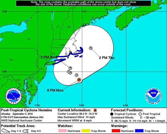
WASHINGTON, Sept. 5 (UPI) -- Although post-tropical storm Hermine was expected to weaken Monday night, tropical storm warnings were in effect in Long Island, Connecticut and Massachusetts.

Post-tropical cyclone Hermine was located about 150 miles off the eastern tip of Long Island as of 8 p.m. Monday night, and expected to weaken, but forecasters at the National Hurricane Center maintained warnings of strong wind and rain, as well as the potential for devastating storm surge.

Advertisement

Hermine has moved on a mostly northward track through the Atlantic Ocean since moving off the coast of the Eastern United States, but it has started to take a west-northwest direction and is expected to affect the northeast coast.

The storm has maximum sustained winds near 70 mph, with higher gusts, and tropical storm-force winds extending outward up to 230 miles from the storm's center. Sustained winds of 32 mph were observed as far north of the storm as Nantucket, Mass.

Photo by National Hurricane Center/National Oceanic and Atmospheric Administration

As of Monday night, the NHC maintained tropical storm warnings for the coast of Long Island from Fire Island Inlet to Port Jefferson Harbor, from New Haven, Conn., to Sagamore Beach, Mass., Block Island, R.I., Martha's Vineyard and Nantucket. The NHC also said in its 8 p.m. update Monday night that the chance for inland watches and warnings remains.

Advertisement

NHC forecasters said in the update that if storm surge occurs at the time of high tide the coast of Long Island from Fire Island Inlet to Port Jefferson Harbor could be between 1 and 2 feet.

In Massachusetts, Hermine is expected to produce between 1 and 2 inches of rain across the eastern part of the state through Wednesday, including on Cape Cod and the state's offshore island.

Latest Headlines