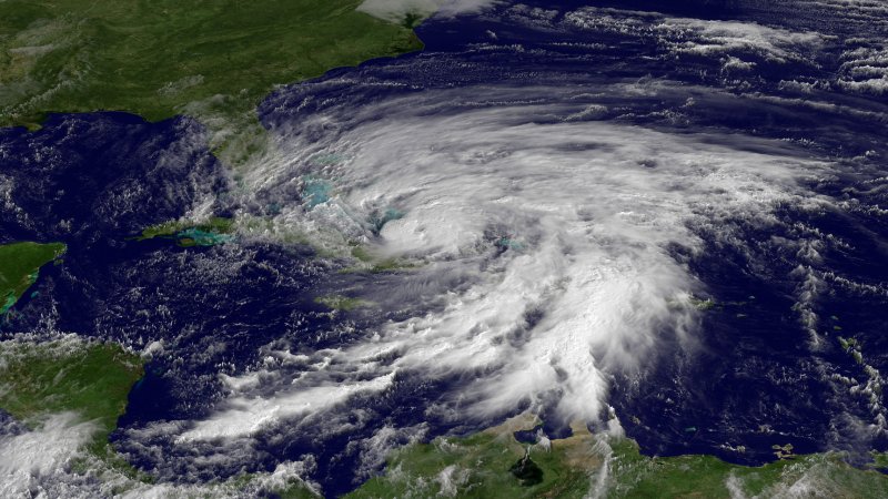
1 of 3 | This NOAA satellite image released on October 25, 2012 shows Hurricane Sandy as it moves northward off the coast of Florida. Sandy is expected to turn toward the northeast on Saturday, followed by a turn to the northwest early next week, with direct impacts expected for the Mid-Atlantic or Northeast U.S. UPI/NOAA |
License Photo
MIAMI, Oct. 26 (UPI) -- Hurricane Sandy Friday targeted the U.S. east coast and possible convergence with an icy storm threatened to create what forecasters dubbed "Frankenstorm."
At 8 p.m. EDT, the National Hurricane Center in Miami said Sandy -- weakened to a Category 1 storm after whipping through the Bahamas -- was moving north at 7 mph with sustained top winds of 75 mph. The storm was 75 miles north of Great Abaco Island in the Bahamas and 400 miles south-southeast of Charleston, S.C.
The storm system began whipping up gale-force winds in southeast and east-central Florida Friday. Some school districts canceled classes. Officials warned residents of dangerous coastal rip currents.
Federal emergency officials were monitoring the situation and coordinating with state officials along the eastern seaboard.
Craig Fugate, administrator of the Federal Emergency Management Agency, urged people to follow instructions from local officials in case evacuations are necessary.
"While the exact track of the storm is uncertain, according to the National Weather Service, storm conditions associated with Hurricane Sandy may impact East Coast states throughout the Southeast, Mid-Atlantic and Northeast as early as tomorrow [Saturday] in some areas," FEMA said.
The storm forced Republican presidential nominee Mitt Romney to cancel a planned campaign appearance in Virginia Beach, Va., Sunday with a state of emergency already declared by Virginia Gov. Bob McDonnell and Maryland Gov. Martin O'Malley, Roll Call reported. New York Gov. Andrew Cuomo also issued an emergency declaration in advance of the storm.
"Due to the track of this storm, and the fact that it will be a hurricane transitioning into a more nor'easter like system, we could see severe weather lasting for 48 hours or more in the state. In that scenario, saturated soil coupled with high winds could lead to major tree damage and extensive power outages," McDonnell said.
A tropical storm warning was extended north along the Florida coast to St. Augustine from Deerfield Beach and the South Santee River to Duck, with a tropical storm watch extending from the Savannah River to the South Santee River and from St. Augustine to Fernandina Beach. Gale watches were in effect further north.
Great Abaco and Grand Bahama islands were still under a tropical storm warning and Bermuda was under a tropical storm watch.
Waves near shore were rising Friday to a forecast 12 feet to 18 feet, with offshore waves 18 feet to 22 feet.
Sandy -- which whipped through the central Bahamas with violent winds and torrential rains Thursday -- killed at least 21 people across the Caribbean.
State media in Cuba said at least 11 people died as Sandy, then a Category 2 hurricane, brought down buildings and trees in the eastern provinces of Santiago and Guantanamo. Haiti reported at least nine deaths and Jamaica reported at least one.
Sandy is forecast to move north from Florida along the Atlantic Seaboard and could combine, in an unusual confluence of weather patterns, with an early winter storm moving eastward from the Great Lakes and a blast of arctic air from the north, forecasters said.
The result could be rain, snow and fierce winds thrashing several Northeastern states starting Tuesday through Halloween Wednesday -- giving rise to the "Frankenstorm" nickname.
Amplifying the weather consequences will be a full moon Monday.
New York, New Jersey and Connecticut -- socked by Tropical Storm Irene last year -- could be hardest hit, forecasters said.


