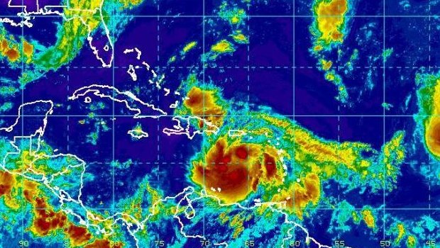
MIAMI, Aug. 24 (UPI) -- Tropical Storm Isaac was on course to make landfall in Haiti, which was already being inundated with heavy rains Friday night, forecasters in Miami said.
In its 11 p.m. EDT Friday advisory, the National Hurricane Center said the center of the storm, with sustained top winds of 70 mph, was 65 miles south-southwest of Port au Prince, Haiti, and 245 miles southeast of Guantanamo, Cuba, as it traveled northwest at 14 mph. The storm was getting better organized at it approached Haiti, forecasters said.
Accuweather.com meteorologist Dan Kottlowski said given the storm's current path, it was more likely to track into the Gulf of Mexico than to hit the eastern side of Florida. There were concerns the storm could disrupt the Republican National Convention, which was scheduled to get under way Monday.
Isaac is currently a strengthening tropical storm in the Caribbean. While some weakening will take place over Cuba, the door will open for rapid intensification once Isaac enters the Gulf of Mexico.
Isaac could quickly strengthen into a Category 2, or possibility a Category 3, hurricane prior to its final landfall, Accuweather.com said, strengthening as it moves into the gulf.
A hurricane watch and tropical storm warning were posted for all of the Florida Keys and for the southern Florida peninsula coast from Ocean Reef on the east to Bonita Beach on the west. A tropical storm warning was in effect for the southeast Florida coast from north of Ocean Reef northward to Jupiter Inlet and for Lake Okeechobee.
The government of the Bahamas issued a tropical storm warning for the northwestern Bahamas.
A tropical storm watch was in effect for the east-central Florida coast from north of Jupiter Inlet to Sebastian Inlet.
A tropical storm watch was posted for the Cayman Islands, as well as Jamaica..
The storm is expected to gain forward speed as it moves northwest Friday night through Sunday. On its forecast track, the center of Isaac was expected to make landfall in Haiti Friday night, and then approach southeastern Cuba Saturday before moving over or near Central Cuba Saturday night. It is expected to approach the Florida Keys Sunday.
Some weakening is expected as the center of the storm crosses Haiti and southeastern Cuba.
Tropical storm-force winds extended 230 miles outward from Isaac's center.
The storm could generate rainfall accumulations of 8-to-12 inches over Hispaniola, with as much as 20 inches in some places -- possibly causing life-threatening flash floods and mud slides.
A storm surge is expected to raise water levels as much as 2-to-4 feet above normal tide levels and the surge will be accompanied by dangerous waves in some areas.
The Federal Emergency Management Agency in Washington said it was monitoring Isaac and -- along with its federal partners through its Regional Headquarters in Atlanta and its Caribbean Area Office -- was in "close coordination with Puerto Rico Emergency Management Agency, Virgin Islands Territorial Emergency Management Agency and the Florida Division of Emergency Management."
FEMA said it has "deployed Incident Management Assistance Teams to Puerto Rico and the U.S. Virgin Islands to coordinate with local officials and to support emergency managers should additional support be requested, or needed."
"Additionally, FEMA has liaisons in Puerto Rico and the U.S. Virgin Islands emergency operations centers, to further strengthen coordination," the agency said in a statement.
"At this time, it is still too early to know whether the storm could pose an immediate threat to the U.S. Coast," the statement said. "History shows that storm tracks can change quickly and unexpectedly, so FEMA encourages coastal residents to monitor weather conditions, follow the direction of local officials, and visit Ready.gov to learn about a few simple steps they can take now to be prepared."