Advertisement

Test burns under way on oil slick

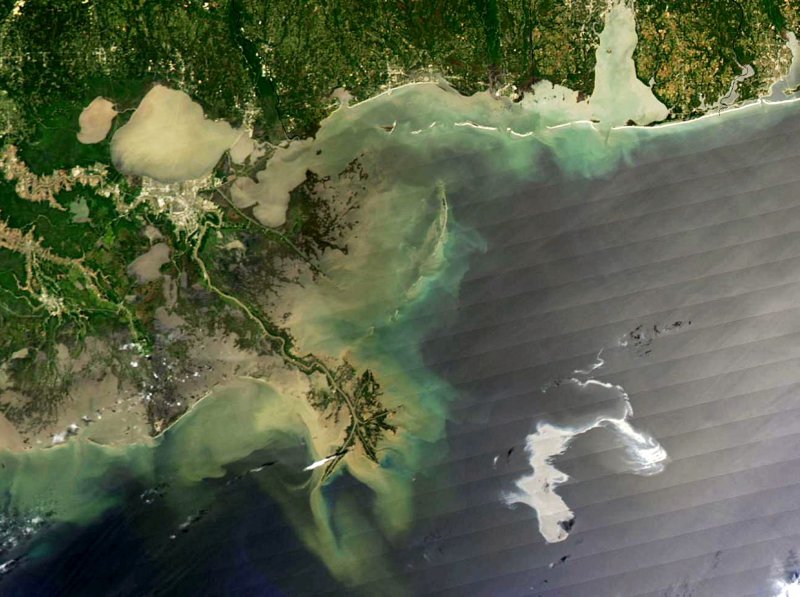
With the Mississippi Delta on the left, the silvery swirling oil slick from the April 20, 2010 explosion and subsequent sinking of the Deepwater Horizon drilling platform is highly visible in this image released Aprils 27, 2010. NASA's Aqua satellite captured this image of the Gulf of Mexico on April 25, 2010 using its Moderate Resolution Imaging Spectroradiometer (MODIS) instrument. The rig was located roughly 50 miles southeast of the coast of Louisiana. New Orleans is up the Mississippi River at left, upper center, just below Lake Pontchartrain. Mobile, Alabama is top right, above the oil slick. UPI/NASA...
1 of 2 | With the Mississippi Delta on the left, the silvery swirling oil slick from the April 20, 2010 explosion and subsequent sinking of the Deepwater Horizon drilling platform is highly visible in this image released Aprils 27, 2010. NASA's Aqua satellite captured this image of the Gulf of Mexico on April 25, 2010 using its Moderate Resolution Imaging Spectroradiometer (MODIS) instrument. The rig was located roughly 50 miles southeast of the coast of Louisiana. New Orleans is up the Mississippi River at left, upper center, just below Lake Pontchartrain. Mobile, Alabama is top right, above the oil slick. UPI/NASA... | License Photo

NEW ORLEANS, April 28 (UPI) -- Preparations were under way Wednesday to try to contain a massive oil slick in the Gulf by setting it afire, U.S. Coast Guard officials said.

If the weather holds, the burning could begin Wednesday, Senior Chief Steve Carlton told the Houston Chronicle. CBS reported from New Orleans tests burns were under way.
Advertisement

Thousands of gallons of crude oil have been spilling into the Gulf of Mexico since the Deepwater Horizon drilling rig exploded and sank last week about 50 miles off the Louisiana coast. Eleven of the more than 100 crew aboard the rig are missing and presumed dead.

With winds out of the northwest, Carlton said a controlled burn would be possible, with smoke blowing out to sea.

The oil slick is estimated at 600 miles in circumference and growing by 1,000 barrels a day. Late Tuesday, it was within 20 miles of Venice, La., the Coast Guard said.

The doomed oil rig belonged to Transocean, which had been drilling a well for British Petroleum.

Latest Headlines