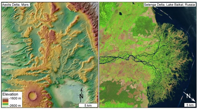
Comparison of exhumed delta in sedimentary rocks on Mars (left) with a modern delta on Earth (right). On the left, a shaded relief map shows elevated, branching, lobate features in Aeolis Dorsa, Mars, interpreted as resistant channel deposits that make up an ancient delta. These layered, cross-cutting features are typical of channelized sedimentary deposits on Earth and here are indicative of a coastal delta environment.
(Credit: DiBiase et al./Journal of Geophysical Research/2013 and USGS/NASA Landsat)
Researchers at the California Institute of Technology have analyzed new high-resolution images from the Mars Reconnaissance Orbiter (MRO) and discovered evidence for a delta where a river may once have emptied into an ocean.
"Scientists have long hypothesized that the northern lowlands of Mars are a dried-up ocean bottom, but no one yet has found the smoking gun," said Mike Lamb, assistant professor of geology at Caltech and coauthor of the study.
Although the discovery of the coastal delta is not proof of an ocean on Mars, lead author Roman DiBiase says the findings, published in the Journal of Geophysical Research, provide some of the strongest support yet.
Most of the northern hemisphere of Mars is flatter and at a lower elevation than the southern hemisphere, appearing similar to Earth's ocean basins.
The Caltech team focused on a 100-square-kilometer area on this possible former coastline, part of a larger region called Aeolis Dorsa, about 1000 kilometers away from Gale Crater where the Curiosity rover is now roaming.
The HiRISE camera on MRO can pick out features as tiny as 25 centimeters long on the surface and the topographic data can distinguish changes in elevation at a resolution of 1 meter. The spacecraft took photos from different orbit points to produce a stereo image of the Martian topography.
The team was able to determine the slopes of the channels and the direction of water flow, indicating the channels were part of a river delta.
Previous Martian deltas were discovered inside a geological boundary, like a crater. Water flowing into a lake enclosed by such a boundary did not provide evidence for an ocean.
But the lack of confining boundary in this case indicates the delta was formed by water flowing into a larger body of water, such as an ocean.
It is still plausible that there was once a confining boundary -- such as a large crater -- that was later erased, Lamb noted.
Researchers plan to continue exploring the hypothetical ocean coastline that separates the northern lowlands from the southern highlands, and analyze sedimentary deposits.
"In our work and that of others-including the Curiosity rover-scientists are finding a rich sedimentary record on Mars that is revealing its past environments, which include rain, flowing water, rivers, deltas, and potentially oceans," Lamb said. "Both the ancient environments on Mars and the planet's sedimentary archive of these environments are turning out to be surprisingly Earth-like."


