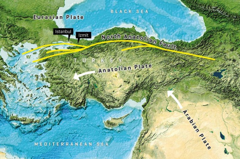
Along the northern coast of Turkey, the Anatolia and the Eurasian Earth Plate rub against each other, forming the North Anatolian fault. Photo GEBCO world map 2014/gebco.net/GEOMAR Helmholtz Center for Ocean Research Kiel
July 9 (UPI) -- It's been more than 250 years since the last major earthquake struck Istanbul, the capital of Turkey. Though the nearby fault system has been silent for two-and-a-half centuries, new research suggests the risk of another major quake is high.
By analyzing shifts in the seafloor, scientists were able to confirm, for the first time, the presence of significant tectonic strain along the North Anatolian fault in the Sea of Marmara.
"It would be sufficient to trigger another earthquake with magnitudes between 7.1 to 7.4," Dietrich Lange, a geophysicist at the GEOMAR Helmholtz Center for Ocean Research Kiel in Germany, said in a news release.
Along the northern coast of Turkey, the Eurasian and Anatolian plates abut, forming the North Anatolian fault, an active strike-slip fault. In 1999, a slip along the fault caused a large earthquake, impacting the city of Izmit and causing 17,000 casualties.
"Strong earthquakes occur when the fault zone becomes locked," Lange said. "Then tectonic strain accumulates, and the seismic energy is released in an earthquake."
For several years, scientists have been closely monitoring the movements of the fault system on land, but a portion of the North Anatolian fault extends into the Sea of Marmara. Tracking underwater fault movements is difficult.
With only imprecise land observations, scientists have struggled to distinguish between a creeping movement and the total locking of tectonic plates. But with the new GEOMAR GeoSEA system, researchers were able to use acoustic distances to precisely measure crustal deformation along the North Anatolian fault.
The system features 10 instruments anchored on either side of the fault half a mile beneath the sea surface. Over the course of 2.5 years, the systems recorded 650,000 distance measurements.
"In order to get measurements accurate within a few millimeters over several hundred of meters, very precise knowledge of the speed of sound underwater is required," said Heidrun Kopp, GeoSEA project manager. "Therefore, pressure and temperature fluctuations of the water must also be measured very precisely over the entire period."
The measurements -- summarized this week in the journal Nature Communications -- showed the fault system is locked up and accumulating strain.
"If the accumulated strain is released during an earthquake, the fault zone would move by more than four meters. This corresponds to an earthquake with a magnitude between 7.1 and 7.4," said Kopp.


