Advertisement

ESA satellite image highlights deforestation in Bolivia

By Brooks Hays
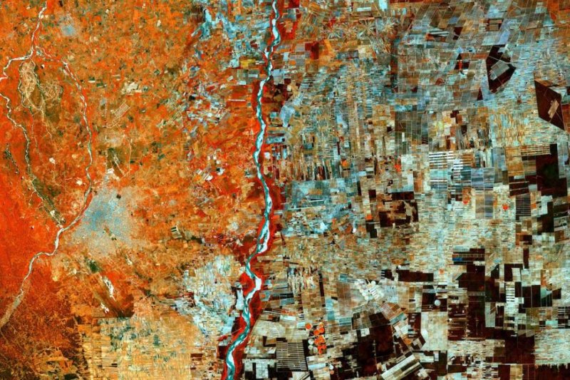
The land surrounding Santa Cruz, Bolivia, once heavily forested, is now a patchwork of farms. Photo by ESA/Copernicus Sentinel

March 22 (UPI) -- As cities expand and more land is converted to agriculture, deforestation is a serious and growing problem throughout the developing world.

An image captured by the European Space Agency's Sentinel-2 satellite offers a snapshot of the problem from an altitude of 488 miles. ESA shared the photo on Thursday in honor of International Day of Forests.
Advertisement

The image features Santa Cruz, one of Bolivia's fastest growing cities. To the east of the city and the Río Grande, a geometric patchwork of agricultural plots dominates. Several decades ago, the right half of this image would be have been a more uniform dark green, the ground below shielded by the canopy of thick Amazonian rainforest.

The fertile soil of the converted forestland has since fueled Bolivia's growing agricultural industry.

"As part of a drive to develop and improve the economy, there has been rapid deforestation since the 1980s to accommodate programs to resettle people from the Andean high plains and develop the area for agriculture, particularly for soybean production," ESA wrote in an update.

While forest conservation efforts have produced important protections in many South American countries, leading to a drop in deforestation rates in the 1990s and early 2000s, the latest data suggests trees are once again being felled at an accelerating rate in Brazil and Bolivia.

Advertisement

Latest Headlines