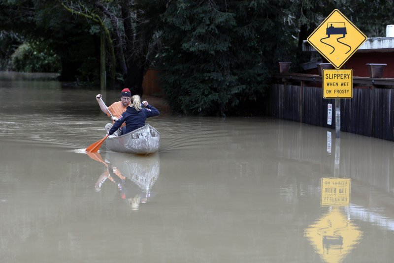
A resident kayaks on a road flooded due to the rising levels of the Russian River in Guerneville Calif., on Monday. The Russian River rose more than four feet above flood level after days of storms in the area. California is expecting record levels of rain. Photo by Monica M. Davey/European Pressphoto Agency
Californians may be getting all the precipitation they wished for, and then some. A wet October followed by a series of big rain and snowstorms kicking off the new year has made for one of the wettest rainy seasons so far in California's record-keeping.
"It's undoubtedly in the top five," said Doug Carlson, an information officer with the state's Department of Water Resources.
As of Tuesday, the rainfall for Northern California was just over 200 percent of average, according to the Department of Water Resources. And the water content of the snowpack statewide was 135 percent of average.
After five years of drought, the precipitation is needed, but it has also caused problems.
"We are navigating both flood and drought at the same time here," said Michael Anderson, the state's climatologist.
The state is still taking stock of the extent of damage, but so far homes have been affected; flooding, landslides and heavy snow have closed roads; several rivers have flooded their banks; and some levees in the Sacramento-San Joaquin Delta are showing weakness and need to be repaired. For the first time in more than a decade, the floodgates of the Sacramento Weir were opened to funnel Sacramento River water to the Yolo Bypass.
"So far, we've been pretty lucky: Quite a bit of water has managed to fall on California over the past couple of months without seeing highly damaging flooding," said Daniel Swain, a NatureNet postdoctoral fellow at UCLA's Institute of the Environment and Sustainability. "This week, we're seeing the first signs of tipping too far in the other direction – quite a few rivers and streams in Northern California have already flooded or will flood shortly. This is a pretty typical feature of California's 'feast or famine' climate: It often takes a flood to break a longstanding drought in this part of the world."
There is no denying that recent precipitation will make a good dent in the state's water deficit, especially when it comes to filling reservoirs. But it's still too soon to fully take stock of the drought impact with the peak of the snowpack still about three months away and two more months left of the heaviest precipitation time, said Carlsen.
"The question will be whether this wet pattern can persist for the rest of the winter, and whether temperatures will be cold enough to maintain a healthy snowpack into the spring," said Swain. Last year, warm temperatures quickly reduced accumulated snowpack in the northern Sierra. "In parts of Southern California, the severity of long-term drought remains quite high, and we would still need to see a prolonged streak of above-average precipitation in that region to bring things back closer to where they should be."
Although recently Southern California has finally been getting some rain, too. "This has been one of the most productive storms over a large area of California that we have probably seen in the last five years," said Jan Null, a meteorologist with Golden Gate Weather Service. Last year, the central and southern Sierra really lagged behind, he said.
Anderson said that although Los Angeles and San Diego both have gotten rain from recent storms, a swath of central California stretching from Santa Barbara County to Tulare County is still missing out.
While the amount of surface water in streams, rivers and reservoirs is promising right now, California will still need years to recoup the over-pumping of groundwater.
"We're still playing the wait-and-see game," said Carlsen. "The rain indexes are remarkably good, the water you can see is looking pretty good, the water you can't see and really wonder about is the groundwater – that's another kettle of fish altogether."
And while the storms may be welcomed now, it's also something the state may need to start getting used to. Swain said that there is still uncertainty about how precipitation in California may change as the climate warms, but the research is stronger when it comes to understanding atmospheric rivers, the kind of storms that have just walloped the state.
"It now appears likely that California will see stronger atmospheric rivers in the future, with an increased risk of extreme precipitation events and flooding," said Swain. "But that doesn't necessarily mean that we're likely to get wetter overall; there's also increasing evidence that we'll actually experience wider swings between drought and flood."
Tara Lohan is managing editor of Water Deeply. This article originally appeared on Water Deeply, and you can find the original here. For important news about the California drought, you can sign up to the Water Deeply email list.
![]()


