Advertisement

Tropical depression forms off Carolinas coast as disturbance gains strength

By Allen Cone
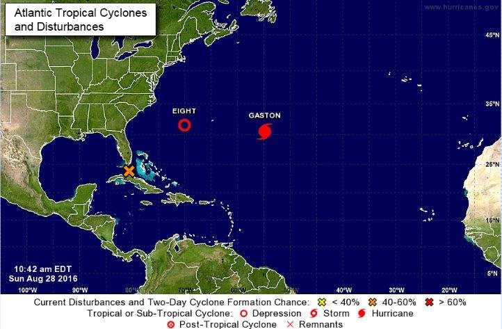
This map Sunday from the National Hurricane Center shows activity in the Atlantic Ocean: Tropical Depression Eight, Hurricane Gaston and Invest 99L (an X).

MIAMI, Aug. 28 (UPI) -- Tropical Depression Nine has formed off the south tip of Florida and is expected to dump several inches of rain on Florida as it moves into the Gulf of Mexico, the National Hurricane Center said.

By Monday the depression is expected to become a tropical storm, with winds already at 35 miles per hour and the depression expected to gather strength from the warm waters of the gulf Monday and Tuesday.
Advertisement

The depression moved away from the Florida Keys on Sunday and is forecast to move toward the state's west coast toward midweek. South Florida can expect heavy rain and scattered thunderstorms and with frequent lightning through Wednesday.

Meanwhile, Tropical Depression Eight formed in the Atlantic Ocean on Sunday as a disturbance gained strength and Gaston became a hurricane again.

The depression is about 355 miles southeast of Cape Hatteras, N.C., and is west-southwest of Bermuda, moving 9 mph with maximum sustained winds of 35 mph.

"There is a possibility this may become the first major hurricane of the season if conditions remain conducive into early [this] week," AccuWeather Meteorologist Ed Vallee said.

Advertisement

Gaston was 600 miles east of Bermuda, moving at 5 mph with maximum sustained winds of 115 mph. Forecasters said further strengthening is possible in the next day or two.

In addition, a tropical wave is expected to move offshore of the west coast of Africa on Tuesday. It has a 60 percent chance of formation over the next five days.

The next hurricane name is Hermine.

In the Pacific, Tropical Storm Madeline was 900 miles east-southeast of Hilo, Hawaii, with maximum sustained winds of 50 mph and was traveling 7 mph northwest, according to the Central Pacific Hurricane Center. It will move near or south of Hawaii by Wednesday or Thursday. The Big Island seems most likely to be impacted by rain and wind.

Also in the Pacific, Hurricane Lester, which was about 950 miles west-southwest of Baja, Calif., was moving westward near 13 mph and maximum sustained winds have decreased to 85 mph. The hurricane is no threat to any land at this time.

Latest Headlines