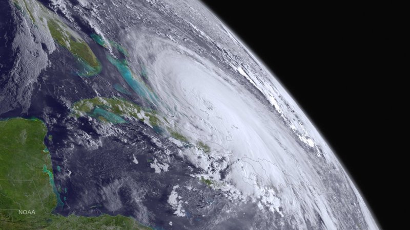
1 of 2 | This NOAA image taken on October 1, 2015 shows Hurricane Joaquin as it travels in the Atlantic Ocean towards the United States. The category 3 storm winds have strengthened to 120 mph. Photo by NOAA/UPI |
License Photo
MIAMI, Oct. 1 (UPI) -- Hurricane Joaquin was upgraded to an "extremely dangerous" Category 4 storm Thursday afternoon with maximum sustained winds of 135 mph winds, the National Hurricane Center said.
The storm was moving slowly to the southwest at about 6 mph, the center said, and was located about 70 miles from San Salvador in the Bahamas. Forecasters expected it to pick up forward speed when it turns north Friday.
Air Force Reserve "Hurricane Hunter" aircrafts found hurricane force winds extend some 45 miles from the center of the storm, and tropical force winds extend about 140 miles.
"Some additional strengthening is possible during the next 24 hours, with some fluctuations in intensity possible Friday night and Saturday," forecasters said.
Residents along the U.S. East Coast were on alert ahead of the storm shifting north, possibly making landfall in the Carolinas or the New York metro area.
Nearly every state from North Carolina to Connecticut was in the so-called "cone of uncertainty." Virginia Gov. Terry McAuliffe, North Carolina Gov. Pat McCrory and New Jersey Gov. Chris Christie declared states of emergency in their respective states. Heavy rains, unrelated to Hurricane Joaquin, have already fallen in the states, increasing the likelihood for additional flooding if Joaquin moves toward the East Coast.
"We know there is definitely going to be moderate and likely to be major flooding events in South Jersey Friday and Saturday with 5 to 6 inches of rainfall expected to come," Christie said in a Thursday morning press conference. "I'm not here to say Sandy II is coming. I have no way of knowing that. But what I want people to know is if it did, we're as prepared as you could be to deal with it."
New York Gov. Andrew Cuomo urged caution, remembering damage from previous storms. The state emergency operations centers was activated Thursday afternoon, and the National Guard is on alert.
"Our state has seen the damage that extreme weather can cause time and time again -- and I am urging New Yorkers take precautions for more heavy storms in the coming days," Cuomo said. "Tropical Storm Lee and Hurricane Irene proved that you do not have to be near the coast to be impacted by Mother Nature. I have directed state agencies to ready their emergency response equipment in partnership with local governments, and I encourage all of our state's residents to be prepared and stay safe."
The National Hurricane Center said the storm's path is still unpredictable but wind speeds should intensify in the coming 24 hours. It will take a sharp turn toward the north on Friday, possibly tracking over North and South Carolina by early next week. Other tracks show the storm moving toward southern New England and Long Island. There is also a chance it will move into the Atlantic Ocean away from land.
Hurricane watches could be posted for portions of the United States coast by Thursday night.
"The range of possible outcomes is still large, and the possibility of a hurricane landfall in the Carolinas still cannot be ruled out," the National Hurricane Center said. "Because landfall, if it occurs, is still more than three days away, it's too early to talk about specific wind, rain or surge impacts from Joaquin in the U.S."
The storm has already dumped more than a foot of rain in the Bahamas and will continue battering the island chain for the next day or so. Forecasters said it could produce up to 20 inches of rain in some areas of the Bahamas, which could cause flash flooding.
Earlier Thursday, the Bahamian government issued a tropical storm warning for the Turks and Caicos islands. Hurricane warnings were in place in central and northwestern Bahamas, including Abacos, Berry Islands, Eleuthera, Grand Bahama Island and New Providence.
"A very dangerous and life-threatening storm surge will raise water levels by as much as 5 to 10 feet above normal tide levels in the central Bahamas in areas of onshore flow," forecasters said.
In Virginia, authorities were expecting 8 to 10 inches of rain early next week in a state already saturated by heavy downfalls. The executive order in Virginia, which is retroactive to Sept. 29, allows local and state emergency responders to begin preparations for expected flooding and power outages.
"I cannot stress enough the imperative for Virginians to focus on the rainstorms that are headed our way tomorrow and Friday, well before Hurricane Joaquin could potentially impact Virginia," McAuliffe said. "As we continue to track the path of Hurricane Joaquin, I have instructed the Secretary of Public Safety and Homeland Security to make every preparation for a major event Thursday and Friday."
Other areas of the East Coast that have been inundated with rain could be facing flash flooding if the storm moves through. Wednesday, one person died in Spartanburg, S.C. after several cars became trapped under a bridge and submerged. The victim, who has not been identified, was found trapped in a vehicle that was under water.


