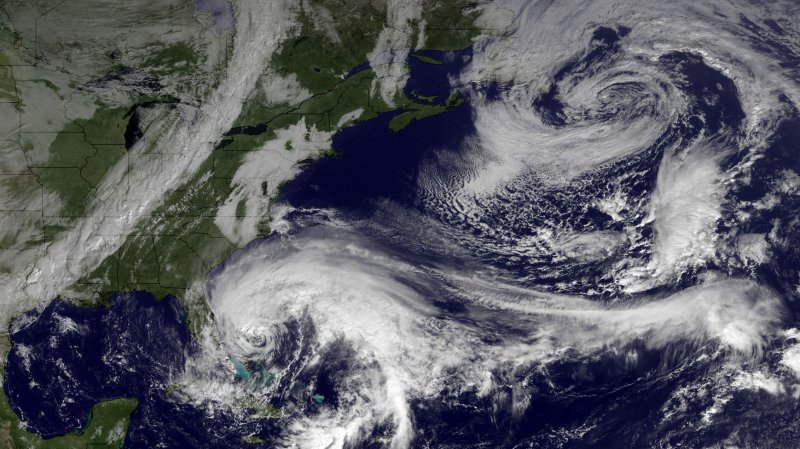
1 of 2 | This NOAA satellite image released on October 26, 2012 shows Hurricane Sandy as it moves northward off the coast of Florida. Sandy is expected to turn toward the northeast on Saturday, followed by a turn to the northwest early next week, with direct impacts expected for the Mid-Atlantic or Northeast U.S. UPI/NOAA |
License Photo
MIAMI, Oct. 27 (UPI) -- Six states and the nation's capital were under states of emergency Saturday and U.S. forecasters said deadly Hurricane Sandy could become a "superstorm."
The development came as forecasters in Miami issued high wind watches and warnings for the mid-Atlantic states and southern New England.
The National Hurricane Center in Miami said in its 8 p.m. EDT advisory that Sandy, already blamed for at least 42 deaths as it swept through the Caribbean on its way to the U.S. East Coast, was producing 75 mph winds as it swirled about 355 miles east-southeast of Charleston, S.C., and about 330 miles south of Cape Hatteras, N.C. The storm was heading to the northeast at 13 mph.
New Jersey and Connecticut Saturday joined Pennsylvania, Maryland, Virginia and New York in declaring a state of emergency, with Gov. Dannel Malloy warning officials in towns near the coast to activate evacuation plans beginning as early as 10 a.m. Sunday and to prepare for "a prolonged evacuation."
"We are going to have to evacuate people for a period of four high tides," Malloy said.
"We expect a large loss of electrical power that we cannot get to quickly and high tides that will exceed Irene and potentially will be worse than the 1938 hurricane," he said.
Malloy said the storm is "more like a monster nor'easter than just a hurricane."
Southern New Jersey could see record coastal flooding when Sandy hits, The New York Times reported computer models project.
There is no avoiding a significant storm surge event over a large area," Rick Knabb, director of the National Hurricane Center in Miami, told reporters Saturday afternoon.
New Jersey Gov. Chris Christie said he was closing the state's 12 casinos closed and ordered the mandatory evacuation of barrier islands south of Point Pleasant. He urged people in Sandy's path to take the dangerous storm seriously.
"Everyone's saying, 'This is crap, it isn't going to happen. The weathermen always get it wrong, so I'm just going to hang out here,'" Cristie said a news conference in Middletown. "Please don't, OK? We have to be prepared for the worst here."
Sandy is expected to merge with a cold front from the west during the weekend. The combined force could force a storm surge into a densely populated region while dumping snow in Appalachia.
The White House said President Barack Obama convened a conference call Saturday with Homeland Security Secretary Janet Napolitano, Federal Emergency Management Agency Administrator Craig Fugate, National Hurricane Center Director Rick Knabb, and Homeland Security Adviser John Brennan.
"The president reiterated his direction to Administrator Fugate to ensure that federal partners continue to bring all available resources to bear to support state and local responders in potentially affected areas along the Eastern seaboard as they prepare for severe weather," the White House said in a statement.
The White House said FEMA was "proactively deploying Incident Management Assistance Teams to multiple states up and down the Eastern seaboard to ensure they have the support they need as they prepare for the storm."
In addition, the agency is conducting daily briefings with state emergency response teams and sending representatives to state and local emergency operations centers. FEMA is also prepositioning water, meals, blankets and other resources at locations along the East Coast.
The hurricane center said Sandy -- which has been on a weeklong trek through the Caribbean and past the Bahamas -- was expected to continue in its current motion through Sunday and then turn toward the north Sunday night, followed by a turn to the north-northwest Monday. On its forecast track, Sandy will move parallel to the U.S southeast coast through the weekend, and approach the mid-Atlantic coast late Monday.
Little change in strength is expected during the next two days.
Hurricane force winds extend about 105 miles from the center of the storm, and tropical force winds extend as much as 520 miles from the center.
All tropical storm watches and warnings have been discontinued along the Florida east coast but the storm could affect a 700-mile region from North Carolina to Maine, CNN reported Saturday.
A tropical storm warning was posted for South Santee River, S.C., to Duck, N.C., as well as for Pamlico and Albemarle Sounds, and Great Abaco and Bahama islands. A tropical storm watch was in effect for Savannah River to South Santee River and Bermuda. Gale, storm and high wind watches were in effect for areas north of the tropical storm warning areas.
New Jersey residents have been stocking up on batteries, bottled water and generators, while bulldozers have been piling mounds of sand around piers along the Jersey shore.
Airlines said they would waive fees for passengers who needed to change flights.


