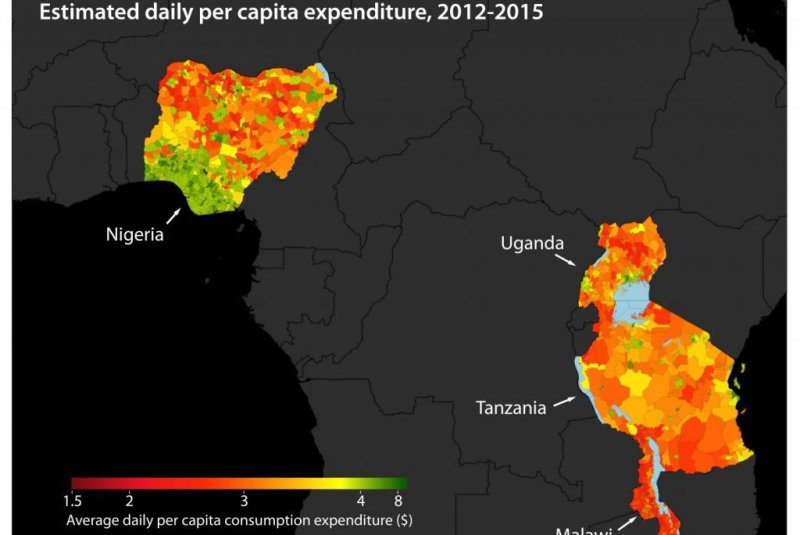
Researchers used the new mapping model to predict poverty levels in several African countries. Photo by Sustainability and Artificial Intelligence Lab/Stanford University
PALO ALTO, Calif., Aug. 18 (UPI) -- Aid groups strategizing about where to deploy resources need accurate information about impoverished populations, but locating those most in need isn't always easy.
Researchers at Stanford University have combined satellite data with machine learning to build a precise map of poverty in Africa.
"We have a limited number of surveys conducted in scattered villages across the African continent, but otherwise we have very little local-level information on poverty," Marshall Burke, an assistant professor of Earth system science at Stanford, said in a news release. "At the same time, we collect all sorts of other data in these areas -- like satellite imagery -- constantly."
Burke is a fellow at the Center on Food Security and the Environment and a co-author of a new paper on the novel mapping technology, detailed this week in the journal Science.
Typically, machine learning is best utilized when algorithms have a vast amount of data to work with. While there's a considerable amount of data included in collected satellite imagery, poverty data remains scarce.
Among the information captured by satellite imagery is the presence of artificial light. Lights shining at night is a sign of economic development. The absence of light, researchers decided, could be used to identify impoverished areas.
Researchers supplied their machine learning algorithms with day and night satellite images, allowing the computer to identify settlements where nighttime lights are few.
"Without being told what to look for, our machine learning algorithm learned to pick out of the imagery many things that are easily recognizable to humans -- things like roads, urban areas and farmland," said lead study author Neal Jean, a computer science doctoral student at Stanford's School of Engineering.
Testing shows the mapping model predicts the presence of poverty more accurately than previous algorithms.
"Our paper demonstrates the power of machine learning in this context," added co-author Stefano Ermon, assistant professor of computer science at Stanford. "And since it's cheap and scalable -- requiring only satellite images -- it could be used to map poverty around the world in a very low-cost way."


