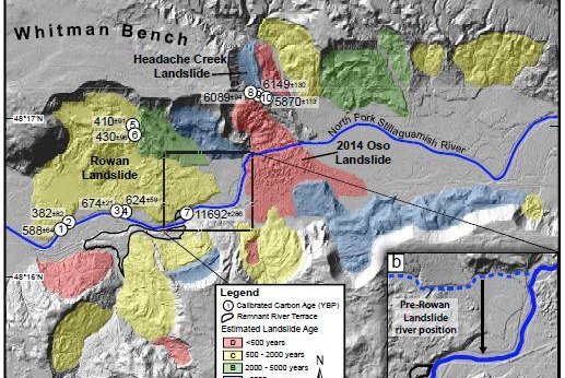
A new map illustrates the chronological history of landslides near Oso, Washington. Photo by the University of Washington
OSO, Wash., Dec. 24 (UPI) -- New analysis of the site of the 2014 mudslide near Oso, Washington, suggests the area has experienced major landslides before, one as recently as 500 years ago. The findings were published this week in the journal Geology.
The 2014 Oso slide buried an entire neighborhood and killed 43 people. But researchers say the catastrophe wasn't an anomaly. The region has a history of dramatic geologic activity.
"The soil in this area is all glacial material, so one hypothesis is the material could have fallen apart in a series of large landslides soon after the ice retreated, thousands of years ago," study co-author Sean LaHusen, a UW doctoral student in Earth and space sciences, explained in a press release. "We found that that's not the case -- in fact, landslides have been continuing in recent history."
Scientists radiocarbon-dated wood debris -- trees and branches dislodged by collapse -- to date two previous landslides in the area. Their analysis showed the much larger Rowan landslide to between 300 and 694 years old. The Headache Creek happened approximately 6,000 years ago.
Establishing these two dates helped geologists to build what's called a roughness curve, enabling the researchers to measure the age of other slides by gauging surface erosion -- without having to dig for ancient debris.
Researchers used a new dating method to study the history of mudslides on a 3.7-mile ridge snaking along a stretch of the north fork of the Stillaguamish River.
"Using our roughness-age curve, we estimate an average Holocene landslide frequency of 1 every 140–500 yr, and show that the 2014 Oso landslide was the latest event in an active history of slope failures throughout the Holocene," researchers wrote in their new paper.
Building a more accurate historical timeline of mudslides can help geologists and policy makers establish improved risk assessments.
"This is the first time this calibrated surface dating method has been used for landslide chronologies, and it seems to work really well," LaHusen said. "It can provide some information about how often these events recur, which is the first step toward a regional risk analysis."


