Advertisement

Google Earth takes viewers to visit polar bears in Canada

Google's Street View Treks goes to Manitoba to film polar bears, takes internet along for the ride.

By Brooks Hays
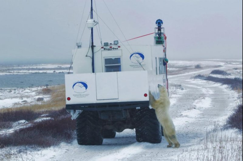
The Street View Trekker, mounted on a "Tundra Buggy," films Churchill’s polar bears. (Google)

CHURCHILL, Manitoba, Feb. 27 (UPI) -- In case internet users hadn't gotten their fill of freezing temperatures and snow banks in real life, Google Street View added its latest online "Trek" today -- a virtual journey to the snowy tundra of Churchill, Manitoba, to track and film polar bears in their natural environs. The expedition, undertaken last fall, was a partnership between Google Maps and non-profit group Polar Bears International. Impressive footage of the remote landscape and the giant white predators that inhabit it was captured using the same panoramic camera technology that enables the street views of Google Maps. The camera was mounted to an extra-hardy "tundra buggy" built by engineers at Frontiers North.

The photography is available for users to explore the same way one would navigate Google Maps.
Advertisement

"There's more to this effort than images of cuddly bears," Polar Bears International executive director Krista Wright wrote today in a post on Google's blog. "PBI has been working in this region for more than 20 years, and we’ve witnessed firsthand the profound impact of warmer temperatures and melting sea ice on the polar bear’s environment. Understanding global warming, and its impact on polar bear populations, requires both global and regional benchmarks."

Advertisement

The Manitoba tundra and its polar bears join Google's other slightly warmer Street View Treks destinations, the Brazilian rain forest and the Galapagos Islands.

[Google]

Latest Headlines