Advertisement

High-res Icelandic volcano images obtained

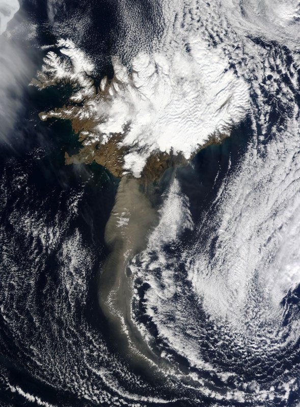
Thick ash poured from Iceland Eyjafjallajokull volcano when the Moderate Resolution Imaging Spectroradiometer (MODIS) on NASAÕs Aqua satellite acquired this image on April 19, 2010, blowing south and then turning east to the United Kingdom. The ash cloud consists of fine particles of pulverized rock, and potentially can cause a catastrophic hazard to aviation. UPI/NASA
1 of 2 | Thick ash poured from Iceland Eyjafjallajokull volcano when the Moderate Resolution Imaging Spectroradiometer (MODIS) on NASAÕs Aqua satellite acquired this image on April 19, 2010, blowing south and then turning east to the United Kingdom. The ash cloud consists of fine particles of pulverized rock, and potentially can cause a catastrophic hazard to aviation. UPI/NASA | License Photo

PITTSBURGH, April 27 (UPI) -- A U.S. volcanologist has compiled the first high-resolution visible and thermal images of the erupting Icelandic volcano Eyjafjallajoekull.

The images were captured by a joint NASA-Japanese satellite sensor and compiled by University of Pittsburgh Associate Professor Michael Ramsey. The images, scientists said, provide the first clear glimpse of the volcano that has disrupted air travel worldwide since it began erupting April 14.
Advertisement

Ramsey collected images taken by NASA's Earth-orbiting Advanced Spaceborne Thermal Emission and Reflectance Radiometer showing that although the volcano's infamous ash plume is receding, its internal temperature is rising.

Ramsey's work with the radiometer usually centers on the north Pacific region, but the satellite was redirected to Iceland to help scientists at the Iceland GeoSurvey who cannot safely approach the volcano. Ramsey said he has been sharing the images with vulcanologists worldwide.

Ramsey said the images can help scientists determine the plume's chemical composition and thickness, the location of lava flows and the volcano's internal temperature. That data can help better monitor the volcano's activity, particularly its effect on the nearby and much larger volcano Katla. In the past, Katla has erupted every time Eyjafjallajoekull has, although the satellite images so far show no signs of an imminent Katla explosion.

Advertisement

The images are available at http://www.pitt.edu/~mramsey/data/Iceland.

Latest Headlines