Updated: April 6, 2011 at 3:05 PM
Fifteen stunning satellite images of earth (15 images)
From tracking wildfires to gathering intelligence on suspect countries, these photos provide detailed images of our planet.
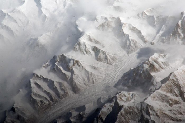
The Tien Shan mountain range is one of the largest continuous mountain ranges in the world, extending approximately 1,550 miles (2,500 kilometers) roughly east-west across Central Asia. This image taken by the Expedition 27 crew aboard the International Space Station provides a view of the central Tien Shan, about 40 miles (64 kilometers) east of where the borders of China, Kyrgyzstan, and Kazakhstan meet. UPI/NASA
License photo | Permalink

This NASA image captured on January 31, 2011 from three images from the Moderate Resolution Imaging Spectroradiometer (MODIS) aboard NASA's Terra satellite were combined to create this image of the massive storm system that is moving across the United States. The storm has dumped over a foot of snow on the midwest. UPI/NASA
License photo | Permalink

NASA's Terra satellite captured a visible satellite image of the Gulf oil spill on May 17, 2010 from the Moderate Resolution Imaging Spectroradiometer Instrument on-board. The oil slick appears as a dull gray on the water's surface and stretches south from the Mississippi Delta with what looks like a tail. From top left to top right are the states Louisiana, Mississippi, Alabama and Florida. Scientists are worried that the huge plumes of oil could get into a current that would take the oil around Florida. UPI/NASA
License photo | Permalink

An ash plume from IcelandÕs Eyjafjallajškull Volcano is seen in this NASA satellite image from April 15, 2010. The eruption sent a plume of ash and steam across the North Atlantic forcing the United Kingdom, Ireland, France, and Scandinavia to close airspace over their countries. UPI/NASA
License photo | Permalink
Advertisement